Vancouver, B.C. – November 7, 2023 - Pacific Ridge Exploration Ltd. (PEX: TSX Venture; PEXZF: OTCQB; PQWN: FSE) ("Pacific Ridge" or the "Company”) is pleased to announce results from diamond drill holes KLI-23-059 to KLI-23-062 from this year’s exploration program at the Kliyul copper-gold porphyry project (“Kliyul” or “Project”). Drill hole KLI-23-062 returned 113.0 m of 0.48% copper equivalent (“CuEq”) or 0.71 g/t gold equivalent (“AuEq”) (0.22% copper, 0.36 g/t gold, and 1.65 g/t silver) within 485.7 m of 0.27% CuEq or 0.40 g/t AuEq (0.15% copper, 0.17 g/t gold, and 0.89 g/t silver). Kliyul is located in the prolific Quesnel Terrane in northcentral British Columbia close to existing infrastructure (see Figure 1).
Pacific Ridge completed a total of 19 diamond drill holes (KLI-23-051 to KLI-23-069) totaling 10,284 metres at Kliyul this year, the largest ever exploration program at the Project. The Company announced drill results for holes KLI-23-051 to KLI-23-054 in August with drill hole KLI-23-054 returning 305.5 m of 0.59% CuEq or 0.87 g/t AuEq (0.23% copper, 0.51 g/t gold, and 1.22 g/t silver) (see news release dated August 23, 2023). Pacific Ridge announced drill results for holes KLI-23-055 to KLI-23-059 in October with drill hole KLI-23-058 returning 103.5 m of 0.63% CuEq or 0.93 g/t AuEq (0.18% copper, 0.66 g/t gold, and 0.93 g/t silver) within 388.5 m of 0.42% CuEq or 0.62 g/t AuEq (0.18% copper, 0.35 g/t gold and 1.05 g/t silver) (see news release dated October 10, 2023). Results for the remaining seven drill holes will be released once they are received and compiled.
Highlights
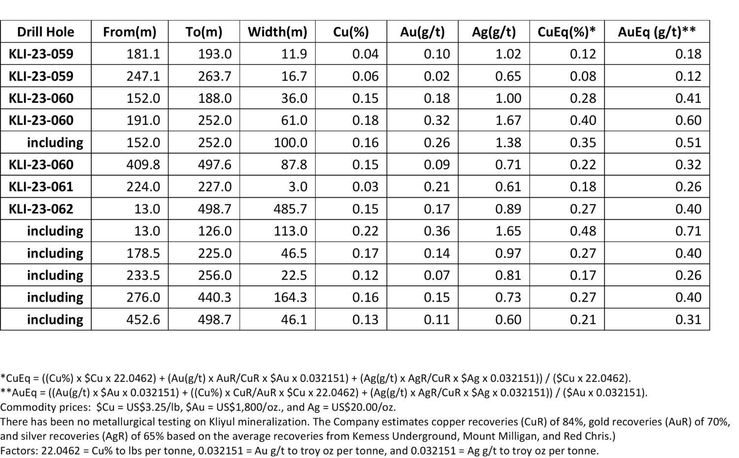
- Drill hole KLI-23-062 returned 113.0 m of 0.48% CuEq or 0.71 g/t AuEq (0.22% copper, 0.36 g/t gold, and 1.65 g/t silver) within 485.7 m of 0.27% CuEq or 0.40 g/t AuEq (0.15% copper, 0.17 g/t gold, and 0.89 g/t silver).
- Drill hole KLI-23-062 is the westernmost drill hole to be completed entirely within the Kliyul Main Zone (“KMZ”). It was drilled vertically to test a gap between KMZ and KMZ West near the intersection of the northwest trending Lui Fault and east-northeast trending Valley Fault and extended porphyry copper-gold mineralization 100 m to the northwest and southwest of the nearest drill holes (see Figures 2 and 3).
- Drill hole KLI-23-060 returned 61 m of 0.40% CuEq or 0.60 g/t AuEq (0.18% copper, 0.32 g/t gold, and 1.67 g/t silver) within 100.0 m of 0.35% CuEq or 0.51 g/t AuEq (0.16% copper, 0.26 g/t gold, and 1.38 g/t silver).
- Drill hole KLI-23-060 was one of three holes, and the westernmost hole, drilled in an east-west fence in KMZ North. KLI-23-060 tested an undrilled area more than 100 m away from any previous drilling and extended porphyry copper-gold mineralization approximately 130 m west of KLI-23-058, which returned 103.5 m of 0.63% CuEq or 0.94 g/t AuEq (0.18% copper, 0.66 g/t gold, and 0.93 g/t silver) within 388.5 m of 0.42% CuEq or 0.62 g/t AuEq (0.18% copper, 0.35 g/t gold and 1.05 g/t silver) (see Pacific Ridge news release dated October 10, 2023).
- Drill hole KLI-23-060 provides further evidence that KMZ mineralization extends across the Valley Fault. KLI-23-060 is 125 m north of the previous northernmost KMZ drill hole KLI-21-036, which returned 291.7 m of 0.79% CuEq or 1.18 g/t AuEq (0.28% copper, 0.74 g/t gold and 2.04 g/t silver within 437 m of 0.64% CuEq or 0.95 g/t AuEq (0.22% copper, 0.60 g/t gold and 1.62 g/t Ag) (see news release dated December 1, 2021).
- Drilling to date has expanded the known extents of KMZ mineralization to 630 m east-west, up to 600 m north-south, and up to 600 m vertical depth. KMZ remains open in every direction.
“I’m very pleased with this batch of drill results,” said Blaine Monaghan, President & CEO of Pacific Ridge. “We continue to grow the known extents of KMZ mineralization and continue to prove that KMZ mineralization pre-dates some of the mapped faults and is not constrained by these faults.”
Figure 1
Location of Kliyul
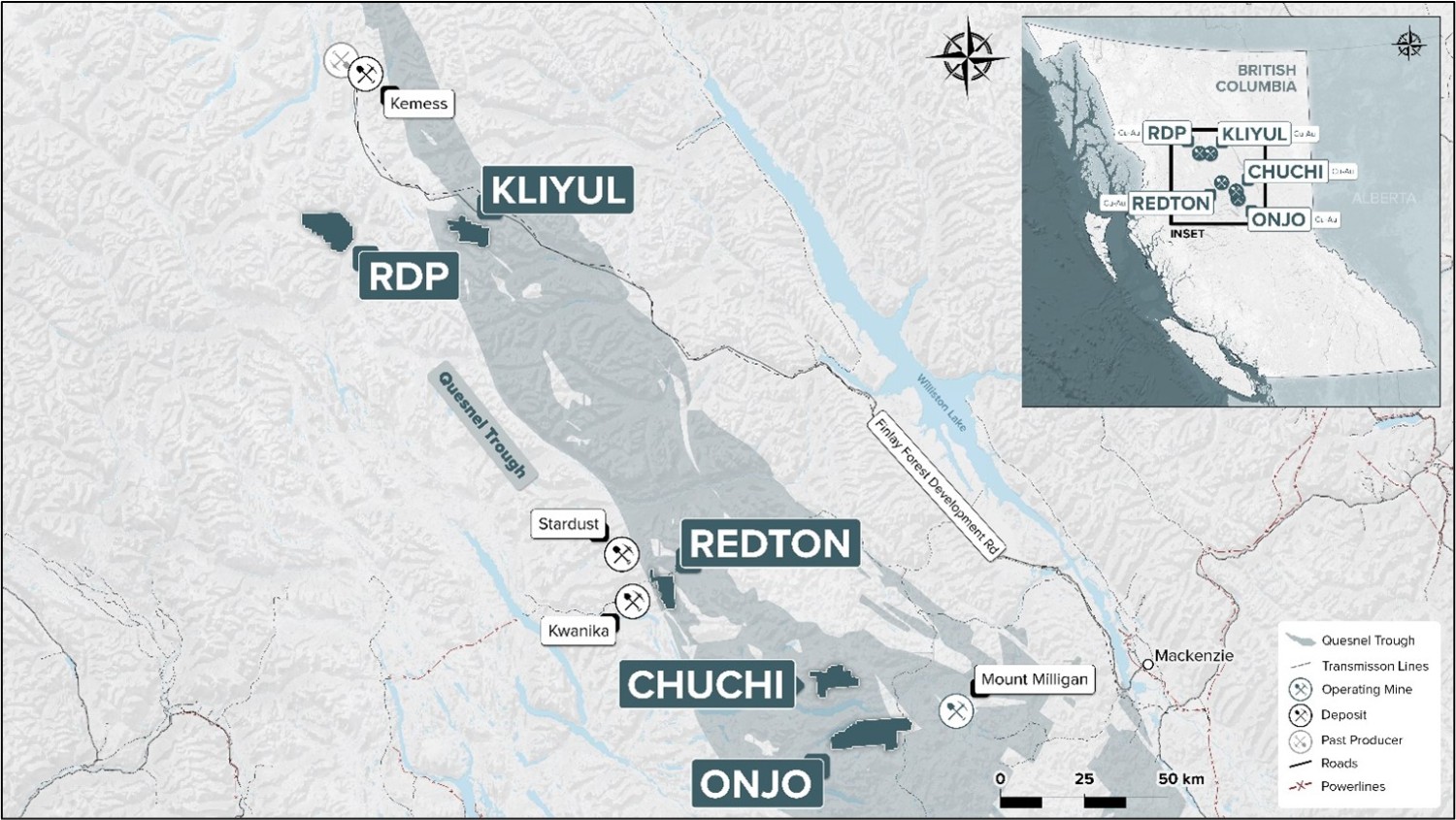
Figure 2
Plan View of KMZ with Magnetic Vector Inversion (“MVI”) Amplitude Magnetics and Tilt Derivative (“TDR”) Anomaly Footprints
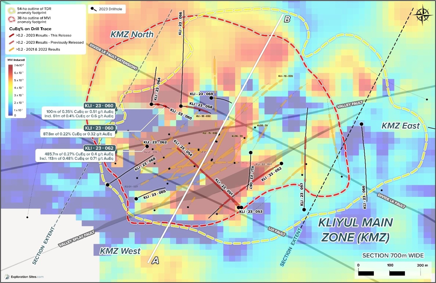
Figure 3
Cross Section – Looking West-Northwest
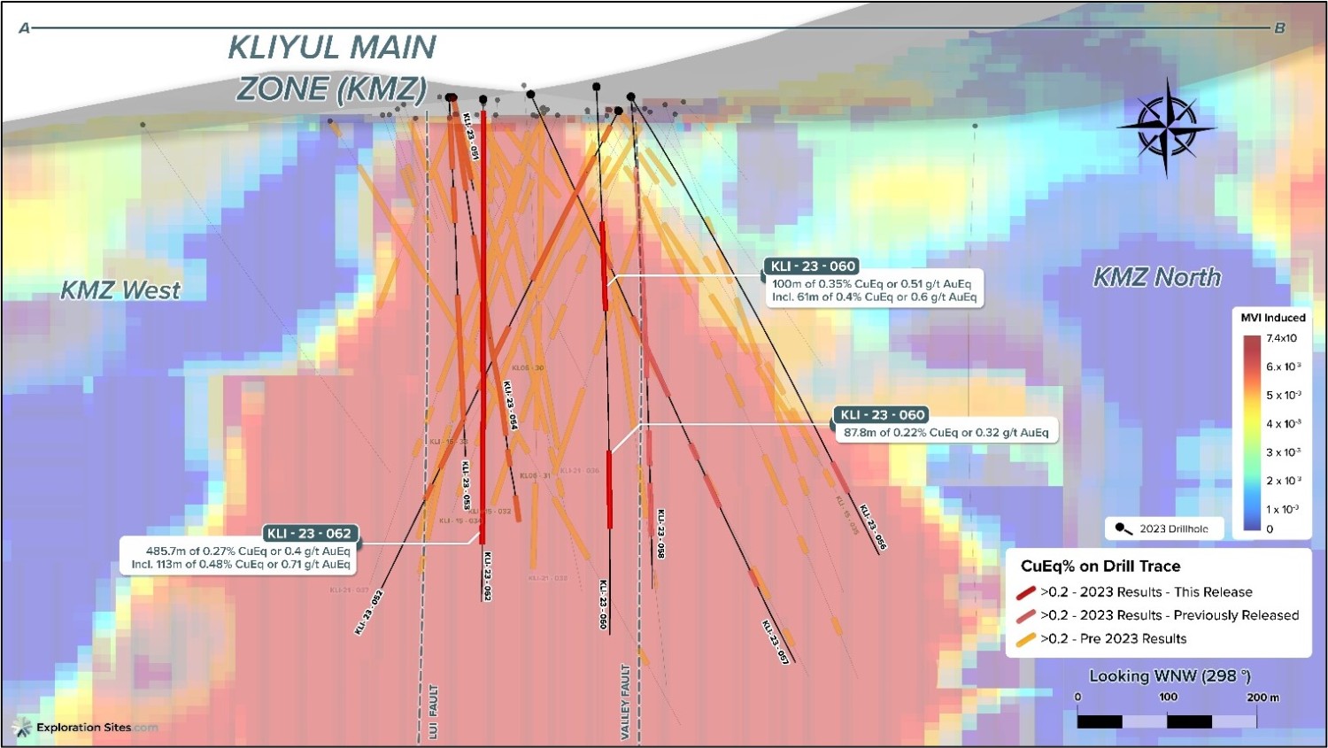
Table 1
2023 Kliyul Assay Results Summary for Drill Holes KLI-23-059 to KLI-23-062
Click on the link below to view drill results from previous holes that Pacific Ridge completed at Kliyul, holes KLI-21-036 to KLI-23-058.
2023-11-06_assay_summary_-_36_to_58.pdf
Discussion of Drill Holes KLI-23-059 to KLI-23-062
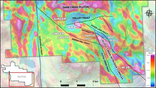
Drill holes KLI-23-059 to KLI-23-062 tested for northern and western extensions of KMZ and several interpreted porphyry centres, Parish Hill and Ginger South (see Figure 4). Parish Hill is 1 km southeast of KMZ within the 6-km-long Divide Lake Fault Trend (NW-SE) and Ginger South is 1.3 km west of KMZ within the 2.5-km-long Valley Fault Trend (ENE-WSW).
Results indicate that mineralization in KMZ extends 100 m farther west into the Lui Fault-Valley Fault intersection area, a junction between KMZ, KMZ West and KMZ North; and continues to the west in the KMZ North in an area without any previous drilling.
- KLI-23-062 returned 113.0 m of 0.48% CuEq or 0.71 g/t AuEq (0.22% copper, 0.36 g/t gold, and 1.65 g/t silver) within 485.7 m of 0.27% CuEq or 0.40 g/t AuEq (0.15% copper, 0.17 g/t gold, and 0.89 g/t silver). It was drilled vertically to test a gap area between KMZ and KMZ West near the intersection of the northwest trending Lui Fault and east-northeast trending Valley Fault. It extended porphyry copper-gold mineralization 100 m to the northwest and southwest of the nearest KMZ drill holes, KLI-21-037 and KLI-15-032.
- KLI-23-060 was drilled 135 m north of KLI-23-062 and returned 61 m of 0.40% CuEq or 0.60 g/t AuEq (0.18% copper, 0.32 g/t gold, and 1.67 g/t silver) within 100.0 m of 0.35% CuEq or 0.51 g/t AuEq (0.16% copper, 0.26 g/t gold, and 1.38 g/t silver). This was the westernmost of three drill holes comprising an east-west fence across the KMZ North and tested an undrilled area more than 100 m away from the closest drill hole, KLI-15-032. It extended porphyry copper-gold mineralization approximately 130 m west of KLI-23-058, which returned 103.5 m of 0.63% CuEq or 0.94 g/t AuEq (0.18% copper, 0.66 g/t gold, and 0.93 g/t silver) within 388.5 m of 0.42% CuEq or 0.62 g/t AuEq (0.18% copper, 0.35 g/t gold and 1.05 g/t silver) (see Pacific Ridge news release dated October 10, 2023). KLI-23-060 provides further evidence that KMZ mineralization is not constrained by the Valley Fault.
Large step-outs from KMZ to the southeast, Parish Hill, and to the west, Ginger South, encountered low grade mineralization over narrow intervals related to skarn or D-vein occurrences. Reconnaissance surface sampling at Parish Hill in advance of drilling confirmed mineralized garnet-epidote ± magnetite skarn and mineralized quartz veins follow a key lithological contact in the Kliyul Creek volcano-sedimentary host rocks near the southeastern end of Lui Fault (see Figure 4).
Figure 4
Kliyul Targets and Relative Magnetic Intensity (RMI) from 2022 Airborne Magnetics Survey
Summary of Drill Holes KLI-23-059 to KLI-23-062
KLI-23-059 (azimuth 225°, inclination -58°, planned length 600 m, drilled length 607 m) was collared at the Parish Hill target, 1 km southeast of KMZ within a broad moderate-intensity RMI aeromagnetic anomaly that follows the Lui fault (see Figure 4). A northwest-trending 330 x 100 m lens-shaped MVI magnetic high anomaly comes to surface here following a lithological contact between Kliyul Creek sandstone-carbonate and volcaniclastic units that was mapped in 2021. This contact has Cu-sulfide mineralized garnet-epidote ± magnetite skarn locally associated. The near-surface MVI magnetic high anomaly dips steeply to the west and merges into a large magnetic high anomaly after 300 m depth that could represent a porphyry deposit source of the surface skarn. Drilling tested this magnetic anomaly.
- Lithology consists of intercalated volcaniclastic andesite, quartz diorite (up to 13.0 m wide) and andesite dykes to 118.9 m. This zone is faulted, sheared and broken to about 90 m. From 118.9-172.2 m there is an augite-phyric pyroxenite unit with a faulted footwall contact. From 223.5-340 m is a zone of alternating plagioclase-phyric flows (up to 28.7 m wide) and a carbonate-volcaniclastic fragmental unit. The remainder of the drill hole is coherent andesite with feldspar porphyry dykes (up to 14 m wide) and a gabbro dyke (53.7 m wide) at 520.6 m.
- Alteration is predominantly chlorite-sericite with lesser sericitic and propylitic to 50.0 m after which propylitic alteration intensifies to moderate. Alteration of the pyroxenite unit includes dolomite, illite, fuchsite; magnetite alteration starts at 128.1 m and biotite alteration increases after 143.5 m towards the pyroxenite footwall contact at 172.4 m. In the footwall zone chlorite-sericite again intensifies and magnetite is replaced by hematite; a shear zone at 181-183 m has a skarn altered appearance and Fe-carbonate. Local garnet-epidote ± wollastonite ± K-feldspar skarn intervals with carbonate occur from 223.5-275.8 m. Below the skarn zone, chlorite-sericite alteration predominates with lesser carbonate and patchy potassic (magnetite ± K-feldspar) to 370.5 m, after which propylitic alteration predominates to end-of-hole.
- Mineralization includes disseminated chalcopyrite associated with skarn intervals. These locally occur with D-veins (quartz-pyrite-chalcopyrite) at 252.0-253.3 m and 319.6 m and with disseminated and stringer pyrite. Trace chalcopyrite and pyrrhotite is noted after 552 m to end-of-hole.
- The 11.9 m interval of 0.12% CuEq or 0.18 g/t AuEq (0.04% Cu, 0.10 g/t Au and 1.02 g/t Ag) from 181.1 m is associated with the skarn altered shear zone. It is also anomalous in tungsten (17.9 ppm). A deeper 16.7 m interval of 0.08% CuEq or 0.12 g/t AuEq (0.06% Cu, 0.02 g/t Au and 0.65 g/t Ag) from 247.1 m is a skarn zone with D-veins and is also anomalous in tungsten (68.3 ppm).
KLI-23-060 (azimuth 90°, inclination -85°, planned length 600 m, drilled length 617 m) was drilled in KMZ North and was the westernmost of three drill holes comprising an east-west fence across KMZ North. It tested an undrilled area over 100 m from any previous KMZ drilling.
- Lithology is mainly volcaniclastic andesite (86%) with feldspar porphyry dykes (up to 64.1 m wide) to 492.9 m. From 492.9-544.3 m is a zone of alternating feldspar porphyry (up to 11.8 m wide) with hornblende andesite dykes (up to 26.3 m wide). From 544.3-613.0 m is volcaniclastic andesite with quartz diorite dykes (up to 9.3 m wide).
- Alteration is anhydrite-bearing inner-propylitic alternating with chlorite-sericite. Weak patchy magnetite alteration starts at 122 m. At 409.8-419.2 there is a sericite cemented breccia and a shear zone from 426.5-437.2 m with intensified inner-propylitic and chlorite-sericite alteration; magnetite alteration becomes moderate strength to 509.5 m. From 509.5 m to end-of-hole local sericitic and chlorite-sericite alteration predominate.
- Mineralization includes disseminated and fracture-fill pyrite. Disseminated chalcopyrite starts with magnetite alteration at 122 m. There is an apparent zonation of vein types with intermediate-stage anhydrite ± epidote ± chlorite ± sulphide veins more predominant from 80.0-475.0 m, and then early-stage quartz ± sulphide veins more predominant from 475.0 to end-of-hole. There is a zone of D-veins between 576.6-586.9 m.
- The 61 m interval of 0.40% CuEq or 0.60 g/t AuEq (0.18% Cu, 0.32 g/t Au, and 1.67 g/t Ag) from 191.0-252.0 m is associated with disseminated pyrite and chalcopyrite, weak magnetite, and inner-propylitic alteration with anhydrite ± chlorite and epidote veinlets at the lower contact and footwall zone of a feldspar porphyry dyke. Interestingly, a 30-cm-wide D-vein (quartz-pyrite-chalcopyrite) with strong sericitic alteration at 584.3 m returned 7.96% CuEq or 11.83 g/t AuEq (0.81% Cu, 10.25 g/t Au, and 35.5 g/t Ag) over a 2 m sample (see Table 1). Indium (0.66 ppm) and tellurium (26.8 ppm) are also anomalous with the vein.
KLI-23-061 (azimuth 055°, inclination -57°, planned length 450 m, drilled length 299 m) was collared at the Ginger South target approximately 1 km south of KLI-23-055, which tested the Ginger target, and 1.3 km west of KMZ. Ginger South lies near the intersection of the ENE-trending Valley Fault corridor with the northwest-trending Parish Hill fault. This interpreted fault intersection is about 250 m north of the planned drill hole collar and coincides with a >0.2 ppm Au-in-soil anomaly. Drilling tested a 150 m diameter aeromagnetic high bullseye anomaly that coincides with a chargeability high. The drill hole was terminated before target depth due to complications with transecting the Parish Hill fault zone, but confirmed the fault exists as modelled.
- Lithology is within the sandstone-carbonate subunit of the Kliyul Creek volcano-sedimentary rocks and comprises alternating volcanic siltstone/sandstone (55%) with carbonate volcaniclastics (26%). Additional units included volcaniclastic andesite and an augite porphyry dyke (18 m wide) with lower contact chilled margin. The Parish Hill fault was encountered at 268 m and is interpreted as a late-stage fault with 70% gouge and rock flour.
- Alteration is chlorite-sericite with lesser sericitic and carbonate alteration. Patchy skarn alteration starts at 84 m and continues to 170.4 m. Weak albite starts at 150.3 m and is bedding controlled. Carbonate volcaniclastic rocks at 170.4 m are dolomite cemented.
- Mineralization includes disseminated and vein-hosted pyrite. Pyrrhotite ± chalcopyrite starts after 38 m associated with late-stage quartz ± calcite veins. Disseminated pyrrhotite, chalcopyrite and sphalerite occur locally.
- The 3.0 m interval of 0.18% CuEq or 0.26 g/t AuEq (0.03% Cu, 0.21 g/t Au and 0.61 g/t Ag) from 224.0-227.0 m is associated with a massive white quartz D-vein (quartz-sericite-chlorite-pyrite). Tellurium is also anomalous (5.8 ppm).
KLI-23-062 (inclination -90°, planned length 350 m, drilled length 563 m) is the farthest west drill hole to be collared and completed entirely within KMZ. It was drilled vertically to test a gap between KMZ and KMZ West near the intersection of the northwest trending Lui Fault and east-northeast trending Valley Fault.
- Lithology is mainly volcaniclastic andesite host rock to 295.3 m. Narrow dykes (< 2.8 m wide) of feldspar porphyry and quartz feldspar porphyry occur at 150 m and 170.2 m. From 295.3-452.5 m is a swarm zone of narrow dykes (1 m to 14.7 m wide) including quartz diorite, feldspar porphyry and hornblende porphyry with intervening volcaniclastic andesite host rock. From 452 m to end-of-hole, volcaniclastic andesite again predominates with local narrow dykes (1 m to 12.2 m wide) of quartz diorite, feldspar porphyry and hornblende porphyry. A flat-lying ductile shear zone is noted at 517-521 m.
- Alteration includes moderate patchy magnetite with overprinting sericit and chlorite-sericite to 142.0 m. After 142.0-170.2 m, magnetite is weak and patchy, occurring with chlorite-sericite and local sericite ± albite ± quartz bleaching. From 170.2-452.5 m, in the dyke swarm zone, is a mix of chlorite-sericite with inner-propylitic (epidote ± albite) alteration and patchy magnetite. From 452.5 m to end-of-hole, sericitic alteration and bleaching again intensifies with locally weak to nil magnetite.
- Mineralization includes disseminated and vein-hosted pyrite and chalcopyrite. Vein types are a mix of intermediate-stage (epidote ± anhydrite ± sulphide) and early-stage (quartz ± magnetite ± chlorite ± sulphide). Within the mineralized dyke swarm, intermediate-stage veins predominate. Intermediate-to-late-stage pyritic D-veins occur with sericitic alteration at the shallow (hangingwall) margin of the dyke swarm and may be related to a megacrystic feldspar porphyry dyke.
- The 113.0 m interval of 0.48% CuEq or 0.71 g/t AuEq (0.22% copper, 0.36 g/t gold, and 1.65 g/t silver) from 13-126 m is associated with moderately strong magnetite alteration with early-stage and intermediate-stage veins. Within this interval at 54-84 m, Zn is anomalous (1,089 ppm) and indium (0.20 ppm). The deeper interval of 0.27% CuEq or 0.40 g/t AuEq (0.16% copper, 0.15 g/t gold, and 0.73 g/t silver) from 276.0-440.3 m is associated with intermediate-stage veins and weak patchy magnetite.
About Kliyul
Owned 100% by Pacific Ridge, the Kliyul copper-gold project (“Kliyul” or the “Project”) is over 60 km2 in size and is located in the prolific Quesnel Terrane close to existing infrastructure. Kliyul hosts a number of compelling exploration targets, including the Kliyul Main Zone (“KMZ”) which has been the Company’s focus since acquiring the Project in 2020. Since then, Pacific Ridge has completed more than 17,500 m of diamond drilling and has expanded the known extents of KMZ mineralization to 630 m east-west, up to 600 m north-south, and up to 600 m vertical depth. KMZ remains open in every direction.
QA/QC (Quality Assurance/Quality Control)
Pacific Ridge’s 2023 exploration program is being managed by Equity Exploration Consultants Ltd. of Vancouver, B.C. The drill contractor is Paycore Drilling of Valemount, B.C. Half-core HQ (63.5 mm) or NQ (47.6 mm) sawed samples from continuous intervals throughout the reported drill holes were sealed on site and shipped to ALS Global Laboratories (“ALS”) preparation lab in Kamloops or North Vancouver, BC. Fire assay and multielement analyses were completed at ALS Minerals analytical laboratory in North Vancouver. Drill core was crushed, pulverized and analyzed for 48 elements using a four-acid dissolution followed by ICP-MS (ME-MS61) with over limits by ore grade four-acid dissolution followed by ICP-AES (OG62), with a 30 g sample analyzed for gold by fire assay and atomic absorption finish (Au-AA23). Blanks and commercially certified reference materials were inserted blind into the sample stream with an overall insertion rate of 5%. Field duplicates representing a quarter core split of the original sample are inserted at 2.5%. Pulp and crush duplicates are inserted at 5% insertion rate by the laboratory. The QAQC results are reviewed as batches are returned from the laboratory and appropriate actions are implemented where required. The QA/QC results for the reported drill holes are acceptable.
About Pacific Ridge
Our goal is to become British Columbia’s leading copper-gold exploration company. Pacific Ridge’s flagship asset is its 100% owned Kliyul copper-gold project, located in the Quesnel Terrane close to existing infrastructure. In addition to Kliyul, the Company’s project portfolio includes the RDP copper-gold project (optioned to Antofagasta Minerals S.A.), the Chuchi copper-gold project, the Onjo copper-gold project, and the Redton copper-gold project, all located in British Columbia. Pacific Ridge would like to acknowledge that its B.C. projects are located in the traditional, ancestral and unceded territories of the Gitxsan Nation, McLeod Lake Indian Band, Nak’azdli Whut’en, Takla Nation, and Tsay Keh Dene Nation.
On behalf of the Board of Directors,
“Blaine Monaghan”
Blaine Monaghan
President & CEO
Pacific Ridge Exploration Ltd.
Corporate Contact:
Blaine Monaghan
President & CEO
Tel: (604) 687-4951
www.pacificridgeexploration.com
https://www.linkedin.com/company/pacific-ridge-exploration-ltd-pex-
https://twitter.com/PacRidge_PEX
Investor Contact:
G2 Consultants Corp.
Telephone: +1 778-678-9050
Email: ir@pacificridgeexploration.com
Neither the TSX Venture Exchange nor its Regulation Services Provider (as that term is defined in the policies of the TSX Venture Exchange) accepts responsibility for the adequacy or accuracy of this release.
The technical information contained within this News Release has been reviewed and approved by Gerald G. Carlson, Ph.D., P.Eng., Executive Chairman of Pacific Ridge and Qualified Person as defined by National Instrument 43-101 policy.
Forward-Looking Information: This release includes certain statements that may be deemed "forward-looking statements". All statements in this release, other than statements of historical facts, which address exploration drilling and other activities and events or developments that Pacific Ridge Exploration Ltd. ("Pacific Ridge") expects to occur, are forward-looking statements. Although Pacific Ridge believes the expectations expressed in such forward-looking statements are based on reasonable assumptions, such statements are not guarantees of future performance and actual results or developments may differ materially from those forward-looking statements. Factors that could cause actual results to differ materially from those in forward looking statements include market prices, exploration successes, and continued availability of capital and financing and general economic, market or business conditions. These statements are based on a number of assumptions including, among other things, assumptions regarding general business and economic conditions, that one of the options will be exercised, the ability of Pacific Ridge and other parties to satisfy stock exchange and other regulatory requirements in a timely manner, the availability of financing for Pacific Ridge’s proposed programs on reasonable terms, and the ability of third party service providers to deliver services in a timely manner. Investors are cautioned that any such statements are not guarantees of future performance and actual results or developments may differ materially from those projected in the forward-looking statements. Pacific Ridge does not assume any obligation to update or revise its forward-looking statements, whether as a result of new information, future events or otherwise, except as required by applicable law.