Vancouver, B.C. – December 13, 2022 - Pacific Ridge Exploration Ltd. (PEX: TSX Venture; PEXZF: OTCQB) ("Pacific Ridge" or the "Company”) is pleased to announce that the 2022 exploration program at the Onjo copper-gold project (“Onjo” or the “Project”), located 10 km west of Centerra Gold Inc.’s (“Centerra”) Mount Milligan mine in northcentral B.C., identified three new porphyry copper-gold targets. The exploration program at the Project consisted of prospecting, geological mapping, a soil sampling program and ZTEM airborne geophysical survey. Onjo hosts skarn and alkalic porphyry copper-gold mineralization associated with dioritic to monzonitic phases of the Witch Lake Diorite.
Highlights:
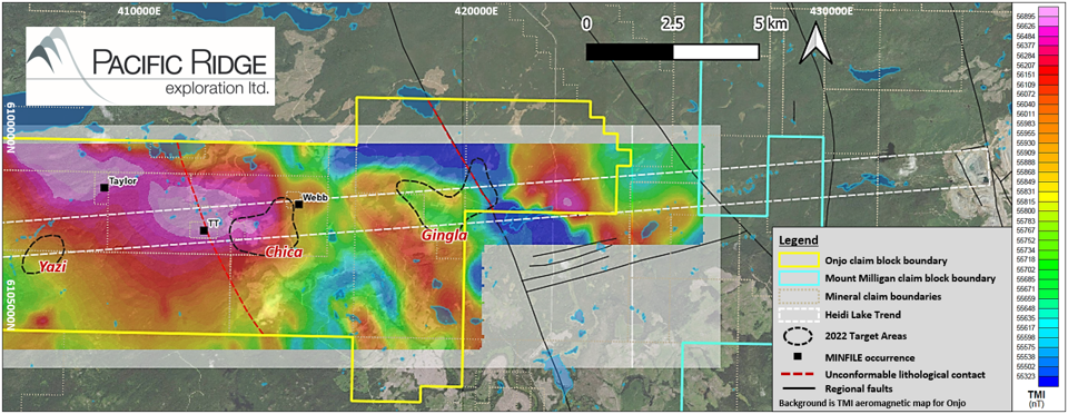
- Three early-stage porphyry Cu-Au targets (Chica, Gingla, and Yazi), defined by ZTEM conductivity, magnetics, and surface geochemistry, occur along an inferred ENE-trending cross-arc structural linear (Heidi Lake Trend) that extends westward from the MBX Main deposit and open pit at Mount Milligan Mine (see Figure 1).
- Electromagnetic results of the ZTEM survey confirm an ENE-trending predominant structural set and secondary north-south and NW-trending structural control. Target zones lie at intersections of these.
- Target zones are at the southern and eastern margin of an aeromagnetic anomaly that is spatially associated with the Witch Lake Diorite composite pluton.
- Intrusion-shaped ZTEM conductivity anomalies of interest are coincident with surface mapping and geochemical sampling results that are anomalous in porphyry deposit pathfinder elements.
Figure 1
TMI Aeromagnetic Map of Onjo. Also Shown is the Inferred Arc-Transverse Heidi Lake Trend Extending Westward from the MBX Main Zone and Open Pit at Mount Milligan Mine
Kliyul Copper-Gold Project and RDP Copper-Gold Project Drill Results Update
Pacific Ridge completed 7,014.7 metres of drilling in 12 holes at the Kliyul copper-gold project (“Kliyul”) in 2022 and reported the first six drill holes in November. Drill hole KLI-22-041 intersected 278 m of 0.67% copper equivalent (“CuEq”) or 0.92 g/t gold equivalent (“AuEq”) within 588 m of 0.41% CuEq or 0.56 g/t AuEq (see news release dated November 16, 2022). Significant porphyry copper-gold mineralization was intersected in every drill hole and the mineralized body at the Kliyul Main zone (“KMZ”) was materially expanded. The Company expects to report the remaining six drill holes from Kliyul in January 2023.
Pacific Ridge completed 1,861 metres of drilling in six holes at the RDP copper-gold project (“RDP”) in 2022 and reported the results from drill hole RDP-22-005 in October. Drill hole RDP-22-005 intersected 107.2 m of 1.41% CuEq or 2.04 g/t AuEq within 497.2 metres of 0.66% CuEq or 0.96 g/t AuEq (see news release dated October 25, 2022). This was the longest, highest-grade interval ever returned from RDP. The Company expects to report the remaining five drill holes from RDP in January 2023.
Further Discussion of the 2022 Exploration Program at Onjo
The ZTEM survey comprised a total of 24 east-west lines that were flown at 250 m line-spacing, and 11 north-south tie-lines that were flown at 2,500 m spacing. In total, there was 679 line-km flown over 140 km2. The quality of the DT (total divergence) images compares well with the TPR (total phase rotated) images. ZTEM is useful in mapping geology and potential porphyry deposit signatures using resistivity contrasts and magnetometer data provides added information on geology using magnetic susceptibility contrasts (see Figure 2).
Figure 2
ZTEM 2D Inversion Section L1080 Crossing the Northern Part of the Central Target Area (Chica) and the Southern Part of the Eastern Target Area (Gingla). Black Dashed Lines are Inferred Faults. Red Dashed Arrows are Interpreted Porphyry System Centres. Inset Map is the ZTEM IP 90 Hz DT Grid; Black Line Represents the L1080 2D Inversion Section
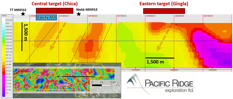
Section L1080 suggests two moderately west-dipping porphyry system target areas (red dashed arrows) separated by six kilometres along the Heidi Lake Trend (see Figure 1). The central target appears to exhibit a strong degree of fault control while the eastern target appears to abut the western edge of a conductive basin, much like the west-dipping MBX Main deposit at Mount Milligan where it is cut off on the east side by a Paleogene basin across the east-dipping Great Eastern Fault.
Total Magnetic Intensity (TMI)
The TMI aeromagnetic map (see Figure 1) suggests the large ESE-trending magnetic anomaly at Onjo is composed of two adjoining magnetic high anomalies, a western anomaly (2.5 km x 1.7 km) and an eastern anomaly (3.5 km x 2 km). The NNW-trending Chuchi Lake succession unconformity runs through the centre of the eastern anomaly. If these represent underlying intrusions of the Witch Lake Diorite complex, then the eastern anomaly must have an Early Jurassic age (age of the Mt. Milligan deposit) or younger. Thus, the margin of this anomaly and inferred pluton is prospective.
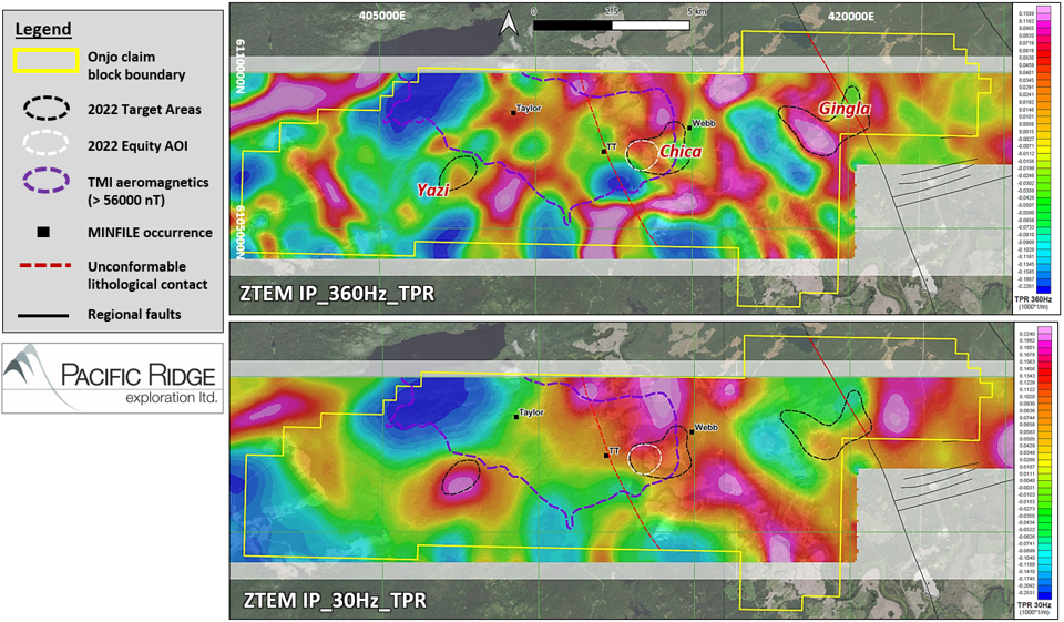
ZTEM (DT, TPR, 2D inversion)
The In-phase TPR maps have highlighted several prominent, moderate size (<3 km2), circular, intrusive-like conductive and resistive tipper anomalies that lie in proximity to the magnetic high in the centre of the block. Three main target areas of interest lie along the principal ENE linear trend that extends across the project (see Figure 3).
- The western target area is a persistent conductivity high feature from 180 Hz to 030 Hz that increases in size and intensity at lower frequencies (at depth).
- The central target area is a N-S trending ellipse-shaped conductivity high anomaly at the eastern margin of the central aeromagnetic high domain and extends beyond the magnetic high to the north. The main area of interest is about 1.5 km east of the western Chuchi Lake succession unconformity situated between the TT and Webb MINFILE areas at the southern margin of the conductivity anomaly.
- The eastern target area is elliptical to circular plug-shaped conductivity high anomaly that is strongest at 360 Hz and weakens with lower frequencies to 030 Hz. On section, the conductivity anomaly has an inverted cup shape (see Figure 2) suggestive of the upper part of a porphyry system. The target lies up to 1.2 km west of the eastern Chuchi Lake Succession unconformity.
Figure 3
ZTEM Survey Total Phase Rotated (TPR) grids. Top is IP_360Hz_TPR and Bottom is IP_30Hz_TPR. Also Shown is Outline of the TMI Aeromagnetic High Anomaly (>56000 nT) and 2022 Target Areas of Interest
Highlights of the prospecting and mapping program:
- An approximately 80 ha area of interest (“Equity AOI”) is located in the centre of the property (see Figure 3) This area contains the highest density of outcrop encountered in the mapping program and exhibits lithology, alteration, and mineralization features suggestive of a hydrothermal porphyry system.
- Mapped alteration and mineralization in the Equity AOI has a NE-SW trend that mirrors a moderate-high conductivity trend at the southern margin of the ZTEM TPR (030 Hz) high anomaly, which is coincident with the southeast margin of the central TMI aeromagnetic anomaly. This moderate-high TPR trend extends from the Equity AOI to Webb MINFILE area (Figure 3).
- Surface geochemical sampling of rocks (see Figure 4) in the Equity AOI is anomalous in Mo, Cu, Se, Bi, As, Sb, Au, and MPIx (MDRU porphyry index), and of soils (see Figure 5) in Mo, Cu, Te, Se, Bi, As and Au. This combination of elements with elevated MPIx suggests proximity above a porphyry Cu-Au system.
- Surface geochemistry in the eastern target area is more muted but there is thicker glaciofluvial and alluvial cover. One rock sample (see Figure 4) is anomalous in Au and Te, and the area includes the highest historical (2020) Cu-in-rock sample value (368 ppm). There is a cluster of relatively high MPIx values in soil overlying the conductivity anomaly (see Figure 5). This target may represent the upper part of a porphyry Cu-Au system.
- The western target area has soils that are anomalous in Mo, Cu, As, Sb and Au (see Figure 5).
Figure 4
Rock Sampling Results Showing Copper, Gold, Molybdenum and MPIx. Background is ZTEM TPR 090 Hz Grid
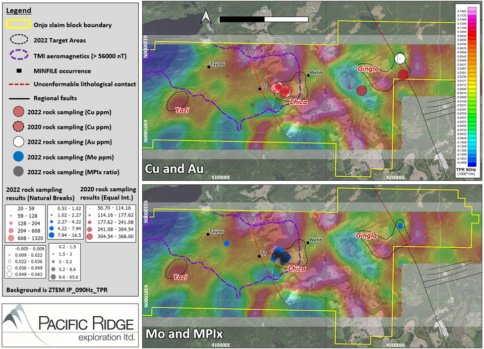
Figure 5
Soil Sampling Results Showing Copper, Gold, Arsenic, Molybdenum and MPIx. Background is ZTEM TPR 090 Hz Grid

Onjo Overview
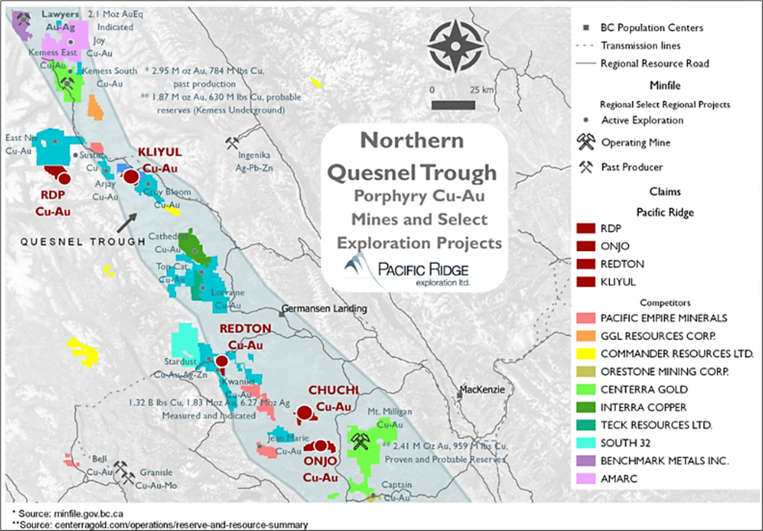
100% owned by Pacific Ridge, Onjo is located in the prolific Quesnel Trough of northcentral British Columbia, approximately 10 km west of Centerra’s Mount Milligan Mine (see Figure 6). Over 12,350 hectares in size, the Project is accessible via a network of forestry roads. The Project hosts skarn and alkalic porphyry copper-gold mineralization associated with dioritic to monzonitic phases of the Witch Lake Diorite pluton which intrudes Takla Group and Chuchi Lake succession volcanic host rocks, similar to the Mt. Milligan deposit geology. Onjo has a long history of mineral exploration by several companies dating to 1960, including mapping, soil geochemistry, numerous geophysical surveys and limited drilling.
Onjo is centered on a large (10 km x 5 km) ESE-trending aeromagnetic high anomaly that is spatially associated with the Witch Lake Diorite pluton. This anomaly is comparable to other multi-kilometre scale aeromagnetic high anomalies in the Nation Lakes District including a 12 km x 6 km NW-trending anomaly which, at its southern end, underlies the Mount Milligan mine. Exploration target areas at the Project, including three MINFILE occurrences, overlie the Witch Lake pluton aeromagnetic anomaly or lie along its margin on the east and south sides. Similar to the anomaly at Mount Milligan, its large scale may be obscuring the more subtle geophysical signature of mineralized Early Jurassic monzonite porphyry stocks or dykes along its margin.
The style of copper-gold mineralization returned in historical drilling, combined with the presence of nearby skarn occurrences, leads Pacific Ridge to believe that past operators at Onjo encountered the upper levels of an alkalic porphyry system. Based on this hypothesis, the Company postulates that the Project has the potential to host an alkalic porphyry copper-gold deposit at depth.
Figure 6
Location of Onjo
About Pacific Ridge
Our goal is to become British Columbia’s leading copper-gold exploration company. Pacific Ridge’s flagship project is the Kliyul copper-gold project, located in the prolific Quesnel Trough, approximately 50 km southeast of Centerra Gold Inc.’s Kemess mine. In addition to Kliyul, the Company’s project portfolio includes the RDP copper-gold project (optioned to Antofagasta Minerals S.A.), the Chuchi copper-gold project, the Onjo copper-gold project, and the Redton copper-gold project, all located in British Columbia.
On behalf of the Board of Directors,
“Blaine Monaghan”
Blaine Monaghan
President & CEO
Pacific Ridge Exploration Ltd.
Corporate Contact:
Blaine Monaghan
President & CEO
Tel: (604) 687-4951
www.pacificridgeexploration.com
https://www.linkedin.com/company/pacific-ridge-exploration-ltd-pex-
https://twitter.com/PacRidge_PEX
Investor Contact:
G2 Consultants Corp.
Telephone: +1 778-678-9050
Email: ir@pacificridgeexploration.com
Neither the TSX Venture Exchange nor its Regulation Services Provider (as that term is defined in the policies of the TSX Venture Exchange) accepts responsibility for the adequacy or accuracy of this release.
The technical information contained within this News Release has been reviewed and approved by Gerald G. Carlson, Ph.D., P.Eng., Executive Chairman of Pacific Ridge and Qualified Person as defined by National Instrument 43-101 policy.
Forward-Looking Information: This release includes certain statements that may be deemed "forward-looking statements". All statements in this release, other than statements of historical facts, that address exploration drilling and other activities and events or developments that Pacific Ridge Exploration Ltd. ("Pacific Ridge") expects to occur, are forward-looking statements. Although Pacific Ridge believes the expectations expressed in such forward-looking statements are based on reasonable assumptions, such statements are not guarantees of future performance and actual results or developments may differ materially from those forward-looking statements. Factors that could cause actual results to differ materially from those in forward looking statements include market prices, exploration successes, and continued availability of capital and financing and general economic, market or business conditions. These statements are based on a number of assumptions including, among other things, assumptions regarding general business and economic conditions, that one of the options will be exercised, the ability of Pacific Ridge and other parties to satisfy stock exchange and other regulatory requirements in a timely manner, the availability of financing for Pacific Ridge’s proposed programs on reasonable terms, and the ability of third party service providers to deliver services in a timely manner. Investors are cautioned that any such statements are not guarantees of future performance and actual results or developments may differ materially from those projected in the forward-looking statements. Pacific Ridge does not assume any obligation to update or revise its forward-looking statements, whether as a result of new information, future events or otherwise, except as required by applicable law.