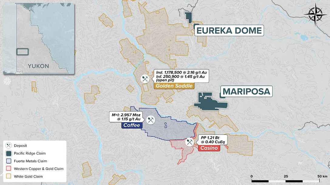
Mariposa
-
Summary
The Mariposa property lies centrally within the Yukon’s White Gold District of the Dawson Range Mineral Belt, a regional major northwest trending structural corridor which hosts numerous gold and copper deposits. It is located 120 kilometres southeast of Dawson City, 40 kilometres southeast of White Gold’s Golden Saddle discovery and 30 kilometres east-northeast of Newmont's Coffee property. The property includes 1,438 claims covering a 30 x 10 km area, or approximately 295 km2.
The geological setting of the Property is similar to the White Gold and Coffee properties in terms of the host lithologies, the structural controls and brittle style of deformation and the nature of gold mineralization. Prior exploration identified an open-ended seven km long horizon of altered, pyrite-bearing quartz mica schist in the Skookum Zone area of the property. This unit is locally flanked by intrusive and mafic rock units, a setting favorable for hosting a gold-mineralizing system.
Recent prospecting at the Hackly Zone resulted in the discovery of mineralized float. Seven samples collected from quartz vein and stockwork material averaged 2.50 gpt Au and 5.67 gpt Ag, with the highest, 9.75 gpt Au and 15.7 gpt Ag from a hematite-rich sample of quartz vein.
Exploration Highlights
Significant drill intersections at Skookum Main, the best being 2.44 grams per tonne (“gpt”) gold over 39 metres.
- Trenches in the Skookum Main area exposed widespread fractured, oxidized rock with local quartz breccias and veinlets. Best results included 1.25 gpt gold over 30 metres within a 150 m interval that ran 0.493 gpt gold (See Table I, below).
- 14 of 18 holes drilled at Skookum Main intersected gold mineralization within steeply dipping, brittle structures. The gold mineralized zone lies within an open-ended corridor of a large and strong gold soil geochemical anomaly that is closely coincident with a linear magnetic low that appears to define a structurally controlled alteration zone within the Mariposa Fault (See Tables II and III, below).
- Six high priority targets (Skookum Main, Skookum West, Big Alex, Maisy Mae, Hackly and Alberta Creek) defined by gold and multi-element soil anomalies identified within the Mariposa Fault Zone.
- Prospecting has located anomalous rock samples in the Skookum Main area including 8.1 gpt gold in the main showing area and 2.3 gpt gold downslope. Anomalous silt samples draining this area also returned anomalous results of in the 100’s of ppb gold range.
In 2013, new, focused exploration techniques developed by Shawn Ryan and Ground Truth Exploration specifically for the White Gold District were applied at Mariposa in order to define targets for on-going drill testing. The IP surveys provided excellent detail in the modelled chargeability and resistivity profiles, particularly in the top 30 to 50 m of the profiles. In many cases, patterns that appear to reflect structures occur immediately beneath gold anomalies in soils, trenches and deep-penetrating Geoprobe soil and rock samples.
At Skookum Main, the Geoprobe survey encountered a 3.08 gpt gold sample in an area not tested by drilling and 100 m along the structural trend, as indicated by geophysics, from the best Skookum Main drill intersection. At Skookum West, the Geoprobe identified a new target, untested by trenching or drilling, with two samples of 7.201 gpt gold and 3.488 gpt gold. At Alberta Creek, the Geoprobe encountered numerous samples in the ).2 to 2.9 gpt gold range over a 100 m by 100 m area, the limit of the sampling program. In all three cases, the sampling indicates a potentially significant bedrock gold source.
In 2015, the Company completed a 12-hole, 655.3 m rotary air blast (“RAB”) drill program at the Skookum Zone. The results demonstrate continuity of mineralized structures to shallow depth for a strike length of 125 m within the Skookum Main mineralized zone (see Table IV, below).
Geological Setting
The Property is located within the central Dawson Range, southwest-central Yukon, where it forms part of a regional polymetallic mineral belt associated with Early Jurassic to latest Cretaceous magmatism. It lies entirely within the Yukon‐Tanana Terrane (YTT). The YTT consists of Late Devonian to Late Permian metamorphic rocks, including various metasedimentary and metavolcanic assemblages and metaplutonic rocks. In the Dawson Range, the YTT typically includes metasedimentary and metavolcanic rock sequences predominantly composed of quartz‐mica schist and diorite gneiss. The magmatic episodes range in age from late Paleozoic to Tertiary.
The Mariposa property is underlain by a poly-deformed sequence of Permian through to Jurassic age metamorphic rocks that have been intruded by discontinuous bodies of mafic – ultramafic intrusions, Cretaceous quartz monzonite and granite intrusions, and feldspar porphyry dykes and small intrusive plugs. The Permian to Jurassic rocks are considered to be ‘basement’ and host gold mineralization on the Mariposa property where they form a NW-striking, variably NE-dipping sequence.
Early Exploration History
The history of gold exploration within the Property dates to 1898, when gold was first discovered in Scroggie and Mariposa Creeks. The first mechanized mining began in the mid 1950’s, while large scale mechanized mining began in 1980 and has continued uninterrupted up until the present. It has been estimated that approximately 100,000 ounces of gold with a fineness of 905 has been produced from Mariposa and Scroggie Creeks.
The first lode gold exploration in the area was reported in 1917, when claims were staked over a reported quartz vein occurrence in the area of the Mariposa Creek placer workings in the general vicinity of the current Skookum Main Zone anomaly. Interest in lode gold exploration picked up in the early 1970’s, with the porphyry copper exploration boom in the Dawson Range, but it is only during the past 12 years that a sustained exploration effort has been carried out on the Property, including ridge and spur prospecting, grid geochemical sampling, geophysical surveys, trenching and two seasons of diamond drilling.
2009 to 2015 Exploration Results
The Company carried out initial soil sampling, prospecting, and mapping late in the 2009 field season and confirmed the 2 km long Skookum Zone gold anomaly. From 2010 through to the end of the 2012 field season, the Company spent approximately $6 million exploring the Property.
The 2010 exploration program included prospecting, rock sampling, grid soil sampling and trenching in the area of the newly discovered Skookum Main anomaly. 2,952 auger soil samples defined a strong gold anomaly approximately 600 m by 1,100, with peak gold values to 1,570 parts per billion (“ppb”). Five trenches were completed for a total of 1,605 m over the Skookum Main zone (Table I). Soil sampling defined other targets at Skookum West, Hackly Gold, Maisy May and Big Alex.
The 2011 program included ground magnetometer and VLF geophysical surveys over the Skookum Main Zone, an airborne magnetometer survey over the west central portion of the Property and 6,903 soil samples collected largely over the Skookum Main and Alberta Creek target areas. Between 19 June and 15 September, 6,011 m of core drilling was completed in 41 holes (Table II).
The 2012 exploration program included the collection of 2,635 soil samples, 175 line km of ground magnetic surveying, approximately 1650 m of excavation in 19 trenches and 2,450 m of diamond drilling in 14 holes (Table III).
Soil Geochemistry: Soil geochemical surveys have been effective in defining the main anomalous zones on the Property. The strongest gold anomalies occur at Skookum Main, Skookum West and Alberta Creek. Weaker and less continuous gold anomalies occur at Skookum East and Skookum North, but this weakened pattern may be due to the presence of extensive areas of permafrost within these zones. Another gold anomaly of interest is the Big Alex Zone, adjacent to the Scroggie Creek placer workings. The Hackly Zone occurs immediately above a placer mining area on Mariposa Creek, noted for pristine nuggets that appear to be close to their bedrock source. The Lou Linear, Gertie and Maisy May targets have a base metal signature and may be related to metal-enriched stratigraphic horizons. There is a strong Mo-Cu zone at the west end of the Alberta Creek gold anomaly.
Geophysics: Magnetic surveys are effective in defining stratigraphic trends and cross structures where they disrupt those trends. At the Skookum Zone, a number of east-northeast trending cross-structures have been defined. These structures are believed to be important in localizing gold mineralization at all the major properties in the district, including Coffee, Golden Saddle and QV. The Maisy May and Skookum Zone anomalies occur within a 2 km wide, east-northeast trending corridor of structural dislocation. More locally, many gold-bearing structures are magnetic lows, possibly due to magnetite destruction by hydrothermal fluids.
Trenching: Trenching of the Skookum Main anomaly produced one very strong result of 1.25 gpt Au over 30 m, within a 150 m interval of 0.49 gpt Au in trench SJ-02. The 2012 trenching program followed the completion of the drill program and focused on the Skookum West Zone. These trenches intersected several significant zones of anomalous gold, including 2.45 gpt Au over 10 m in trench 12-03, 1.49 gpt Au over 4 m in trench 12-05, 1.49 gpt Au over 10 m in trench 12-08 and 1.40 gpt Au over 40 m, including 1.83 gpt Au over 20 m, in trench 12-11 (Table I).
Drilling: The majority of the 2011 drill program targeted Skookum Main (18 holes - 3,005 m) and Skookum West (14 holes - 1,671 m), with additional holes drilled at Maisy May (4 holes - 754 m), Gertie (2 holes - 282 m) and Hackly (2 holes - 299 m). The 2012 drill program focused on the Skookum Main Zone (11 holes – 2,202 m), in particular to test possible north-south controls on mineralized structures as well as defining the geometry of the mineralized zone. Three additional 2012 holes comprising 423 m drilled were bored at Big Alex (Tables II and III).
The first drill hole, testing beneath the highest gold values in trench SK-02, intersected 2.44 gpt Au over 38.9 m (including 6.44 gpt Au over 11.1 m), within an 81.5 m intersection grading 1.51 gpt Au. Several other holes in Skookum Main intersected anomalous gold (+0.5 gpt Au), but it was not until late in the 2012 drill program that the controls on mineralization were fully understood. In addition to being controlled by east-northeast (070o), steeply south dipping structures, there is a stratigraphic control on gold mineralization. Gold is preferentially hosted in felsic units and is significantly reduced in mafic units.
The geological setting for the Skookum Main gold zone is a 75 metre wide, steeply dipping, northeast trending corridor of strongly limonitic fractures and breccias with local quartz veining. This zone of brittle deformation is variably altered and cut by local pegmatite and quartz-feldspar +/- pyrite veinlets and quartz breccias. Anomalous gold values are typically associated with potassium feldspar flooding and veinlets and increased pyrite content.
Drilling at Skookum West was generally disappointing, with + 1 gpt Au values over a maximum of 4.5 m. Narrow, lower grade intersections were also encountered at Maisy May. At Big Alex, the best result was 4.1 gpt Au over 1.8 m in a zone of strong alteration, suggesting significant potential remains at this target.
2013 Program Results: The 2013 program had the objective to more fully define targets for on-going drill testing. The work included the collection of 134 samples at Alberta Creek, 11 high resolution IP/resistivity survey lines (420 m each) at Skookum West, Skookum Main and Alberta Creek and 8 lines of 100 to 150 m each (5 m sample spacing) of deep penetrating, close-spaced soil and rock sampling (Geoprobe). The Geoprobe survey collected 5 m spaced samples over potential structures as indicated by the IP data. Six lines were surveyed for a total of 208 samples.
Skookum Main - A Geoprobe rock sample from the Skookum Main Zone assayed 3.08 grams per tonne (gpt) Au in an area with no previously detected gold-in-soil anomaly and located 100 m west of the best drill hole result from the 2011-2012 drilling, where hole 11MP-01 intersected 6.44 gpt Au over 11.1 m, within 2.44 gpt Au over 38.9 m. Several other Geoprobe samples were anomalous with values in the range of 0.1 to 0.28 gpt Au, just south of the strongly anomalous 3.08 gpt gold result. Trenching is recommended over this newly recognized gold target prior to drill testing.
Skookum West - Two strongly anomalous Geoprobe rock chip samples of 7.20 gpt Au and 3.49 gpt Au, found approximately 50 m apart, were collected along an interpreted west-northwest trending structure. The 3.49 gram gold value correlates with a previous sampling result of 886 ppb Au over 20 m in a nearby trench. Trenching will be required to determine the orientation and extent of this anomaly prior to drill testing.
Alberta Creek - Geoprobe sampling encountered one strongly anomalous result of 2.92 gpt Au and a number of moderately anomalous results, ranging from 0.12 to 0.91 gpt Au, generally reflecting the spatial distribution of the previously defined 400 x 750 m gold-in-soil anomaly. This anomalous result, when combined with the results of the high resolution IP survey, suggests the presence of a northwest trending gold mineralized structural zone. Trenching is recommended prior to drilling.
2015 Program Results: Skookum Main is a priority target at Mariposa. Previous drill hole 11MP-01 intersected 2.44 grams per tonne (“gpt”) gold over 38.9 m, including 6.44 gpt gold over 11.1 m, as well as a deeper intersection of 6.51 gpt gold over 3.2 m. This was below trench SJ-02 which intersected 1.25 gpt Au over 30 m within a 150 m interval of 0.492 gpt Au. The 2015 RAB program demonstrated the presence of two semi-continuous, higher grade gold structures within the broader, N60oE trending Skookum Main gold zone. The structures appear to dip approximately 50o to the SE and thus the intervals in the table below are interpreted to be close to true thickness (see Table IV, below).
<< two tables here >>