Onjo
-
Target
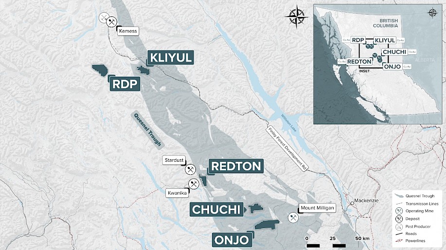
The target at Onjo is a gold-copper porphyry deposit. The project is located in the central Omineca belt and adjoins the eastern property boundary of Centerra Gold’s Mount Milligan mine.
Planned Exploration
The company is completing a comprehensive review of the historical exploration data from Onjo in preparation for a surface exploration program, mapping, sampling, and possible geophysical surveys to define targets for future drill testing.
Project Highlights
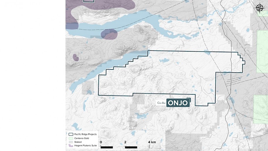
Over 9,700 hectares in size, the road accessible Onjo hosts skarn and alkalic porphyry copper-gold mineralization associated with monzonitic phases of the Witch Lake intrusions cutting Takla volcanic rocks, similar to the mineralization and host rocks at the Mount Milligan Mine. The style of copper-gold mineralization returned in historical drilling, combined with the presence of nearby skarn occurrences, leads Pacific Ridge to believe that past operators at Onjo encountered the upper levels of an alkalic porphyry system. Based on the above exploration hypothesis, the company postulates that the project has the potential to host an alkalic porphyry copper-gold deposit at depth.
Project History
The initial discovery of skarn-type mineralization, at the Taylor showing, was before 1960. The earliest exploration for copper-molybdenum mineralization took place in the 1960’s and 1970’s, with a small soil geochemical survey within the current claim block in 1971. Exploration accelerated in the late 1980’s and 1990’s with the discovery and delineation of Mt. Milligan.
Early explorers at Onjo included Noranda and Placer Dome in the period 1987 to 1992, completing geological mapping, soil geochemical surveys, ground mag, and airborne mag-EM survey and 1,659 m of drilling in 16 holes (Noranda), testing a coincident soil-chargeability anomaly. The drilling encountered propylitically altered basalt, local skarn and altered diorite and Monzonite with low grade copper and gold mineralization. The best intervals included 0.12% Cu over 33 m, 0.07% Cu over 79.7 m and 0.03% Cu and 0.14 gpt Au over 40 m. East of Noranda’s drilling, Moondust Ventures drilled 7 holes, encountering significant pyrite mineralization in altered andesites with minor chalcopyrite, with a best interval of 0.10% Cu over 18 m.
In 2005, Amarc covered a portion of the project with a regional, 500 m line spaced IP survey, with 50 m dipole spacing. During the same time, Serengeti explored a portion of the property with geological, geochemical, and geophysical surveys. In 2009, Serengeti complete two drill holes near the Webb Minfile occurrence, encountering propylitically altered andesite, with pyrite and rare chalcopyrite mineralization. In 2011 and 2012, Serengeti completed 23 line-km of IP and drilled 5 holes for 1301 m.
In 2020, Evrim Exploration Canada Corp., a wholly owned subsidiary of Orogen Royalties Inc., a wholly owned subsidiary of acquired the project by staking and completed a program of historic data compilation, preliminary mapping and geochemical reconnaissance surveying and drill core re-logging. The detailed relogging indicates that Noranda drilling may have intersected the top of an alkalic system.
Setting
Onjo is situated within the 1,300 km long by 35 km wide Quesnel Terrane, which hosts numerous alkalic porphyry copper-gold deposits from southern to northern B.C. In the project area, the Mount Milligan and Lorraine. To the west, deformed and uplifted Permian Cache Creek Group rocks are separated from Quesnel Terrane by the Pinchi fault. To the east, the Manson fault zone separates this belt from the uplifted Proterozoic/early Paleozoic Wolverine metamorphic complex and the Mississippian-Permian Slide Mountain and Cache Creek Groups.