Gold Cap
-
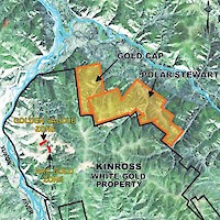
The 56 claim Gold Cap property covers over 1,200 hectares and adjoins the northeast boundary of the White Gold’s Golden Saddle deposit. Gold Cap is 100% owned by Pacific Ridge and was staked in 2009 on the basis of an anomalous gold silt sample reported by the Geological Survey of Canada.
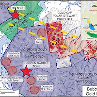
Gold Cap covers a geologic setting for White Gold style mineralization, similar to the Golden Saddle deposit, 6 km to the southwest, which contains an Indicated Mineral Resource of 1,178,500 ounces of gold at 2.16 g/t gold (open pit resource) and an Inferred Mineral Resource of 250,000 ounces of gold (open pit resource) at 1.45 g/t gold (see White Gold news release dated November 19, 2024, for further information). The main target at Gold Cap is a gold soil anomaly. During 2009 and 2010, exploration on the property consisted of detailed grid-based soil sampling to test the emerging geochemical trends. The combined results detected a 3km long northeasterly gold-in-soils anomaly. Gold-in-soil values peak at 217 ppb gold.

The anomaly lies adjacent to the Cathy Zone on the White Gold property and the two soil anomalies may be a part of the same zone. From a regional geological perspective, a major northwest/southeast-trending fault zone proximal to the Comstock gold discovery located 5 km northwest of Gold Cap, may also trend through the Gold Cap claims.
The Company’s 2018 exploration program at Gold Cap included prospecting, geologic mapping, soil sampling and deep penetrating GT Probe soil sampling. The sampling further refined the gold target areas and numerous samples of quartz vein float were encountered, but no bedrock gold source was found.

